Tag Archives: route 66

HIWAY AMERICA ROUTE 66 The Oatman Burros Oatman Arizona

Standard
HIWAY AMERICA ROUTE 66 The Oatman Burros Oatman Arizona

86839748.CnvFUppAimages (305)86841822.iT69qBIC86841830.z1YH5AW9


images (304)images (303)


The Oatman Burros
Should you decide to take a leisurely drive along Historic Route 66 and down through Oatman, don’t be surprised if your journey comes to a sudden halt thanks to some stubborn jackass in the middle of the road. The town is full of them.

I’m not talking about the people, of course. I’m talking about burros. And they’re the reason most visitors stop in Oatman to begin with, whether they’re blocking the way or not. Sure, Oatman’s got a gold-mine tour, Wild West shootouts and an annual egg-frying contest, but it’s the braying beasts of burden everybody comes to see. Come to think of it, it’s probably the only vacation spot tourists flock to in order to be surrounded by asses entirely on purpose.

The burros, though they’ve gotten quite comfortable among humans, are actually wild. It’s estimated there are about 600 feral burros meandering between Kingman and Lake Havasu City, and about a dozen of them enter Oatman on a daily basis. They come down from the Black Mountains of their own accord and invade the town as though commuting to work. When the shops begin to close and the tourists start to leave, they head back out again.

They’re direct descendants of pack animals that were once used in local mining operations. When the federal government shut the mines down in the 1940s in response to the war effort, workers simply let the burros go. They never really left, though, and due to their obstinate charm, Oatman has survived becoming a ghost town, though just barely. As a nearby sign admits, “If it were not for these burros, in all probability, neither you nor this plaque would be standing here today.”

These days, the burros willfully amble among Oatman’s small collection of storefronts, planting themselves along the shoulders and walkways. They persistently beg for handouts, which come in the form of carrots sold in many of the town’s shops. The animals aren’t subtle about it, either. They head-butt their way into car windows and wander directly into the shops to get what they’re looking for. Tourists who neglect to have treats on hand are sometimes chased down the street. Those with an ample supply quickly find themselves outnumbered and drowning in donkey slobber.

Oatman insists the burros are friendly, but still advise visitors to beware. The more zealous of the bunch have been known to mistake fingers for carrot sticks. Kicking isn’t unheard of, either. In fact, the locals recommend you leave the pets at home, as some of the pack tend to see dogs as furry soccer balls.

Donkeys Rule in Oatman
There is a little town northeast of Bullhead City, Arizona called Oatman. It’s on old Route 66. The road is narrow, twisty, and pot-holed. The town is an old gold and silver mining town with lots of character and weird history. Many donkeys roam the streets and they have the right of way. These donkeys are descendants of the pack donkeys the old miners brought to the area. I’m sure that this place is rife with weird stories. —Ken Karnes

HIWAY AMERICA-ROUTE 66 SPRINGFIELD MO.. PART 4

Standard

Springfield is the third largest city in the State of Missouri and the county seat of Greene County.[5] According to the 2010 census data, the population was 159,498, an increase of 5.2% since the 2000 census.[6] The Springfield Metropolitan Area, population 436,712, includes the counties of Christian, Dallas, Greene, Polk and Webster. Springfield’s nickname is the Queen City of the Ozarks and is known as the Birthplace of Route 66 as well as the home of several universities including Missouri State University.


ImageImageImageImageImageImageImageImage<img class=”size-full wp-image” id=”i-src=”https://beatnikhiway.wordpress.com/wp-content/uploads/2014/01/315324_395466237178256_504964314_n.jpg?w=650″ />untitled (57)ImageImage

ncenter” id=”i-10095″ alt=”Image” src=”https://beatnikhiway.wordpress.com/wp-content/uploads/2014/01/1170704_566301986761346_765543900_n.jpg?w=650&#8243; width=”650″ height=”456″ /><a

HIWAY AMERICA AMIRILLO TX. ROUTE 66 PART 6

Standard

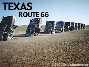
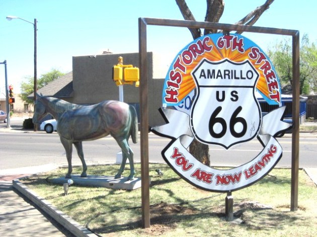
HIWAY AMERICA-AMARILLO TEXAS ROUTE 66

images2jo4tr2t-2AMARILLO BY MORNING BY GEORGE STRAIT   http://youtu.be/k9uLKLhm0Eg

Short about Amarillo

Is a US city in the state of Texas, with a portion extending into Randall County.

Ten fun facts about Amarillo

 Fact 1 The city got its name from a kind of yellow grass that grows in the area. Earlier, the city used to be called Oneida.
Fact 2 Amarillo residents call it the Helium capital of the world because most of the world’s supply of this gas can be located within two hundred and fifty miles of this Texas City.
Fact 3 Amarillo is home to the largest canyon within the state of Texas. Palo Duro Canyon is second only to the Grand Canyon.
Fact 4 Amarillo has a long standing record of being America’s cattle shipping capital. This is partly due to the fact that there are some many large cattle ranches located in this area in the center of Texas.
Fact 5 One of the largest nuclear weapons assembly plants in the United States is located in this city.
Fact 6 The city and the surrounding landscape have been used as a filming location in many popular movies like Indiana Jones and the Last Crusade.
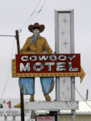
Fact 7 Amarillo has inspired many country singers to write and sing songs about the city.
Fact 8 When the cattle industry sued actress and television personality Oprah Winfrey the case took place in Amarillo.
Fact 9 Famous country singer Lacey Brown calls this city home.
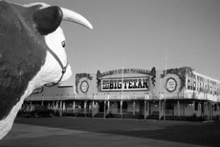
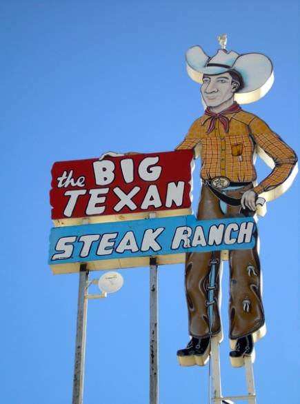
Fact 10 Amarillo is home to the Big Texan steakhouse. The Big Texan serves a 72 ounce steak and they promise that anyone that can eat the dinner completely in less than one hour can have the dinner for free.
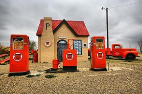
getimage (6) getimage (5) getimage (4) getimage (3) getimage (2) getimage 13 untitled (71)i-jcNKVxb-Th

NORVELL3268Twin Arrows Trading Post, Twin Arrows Arizona, Route 66 Twin Arrows Trading Post, Twin Arrows Arizona, Route 66 Twin Arrows Trading Post, Twin Arrows Arizona, Route 66ImageImageImageImageImageImageImageImageImageImageImage

Aside

HIWAY AMERICA-SPRINGFIELD IL. -ROUTE 66, COZY DOG DRIVE-IN, LINCOLN’S GRAVE AND MEMORIAL

us-map2ImageImageImageImageImageImage

Cozy Dog Drive-In

google map goes here

Description

The restaurant is a shrine to Route 66 and to itself, packed with mementos, clippings, and old signs, as well as with Mother Road souvenirs for sale. The “corn dog on a stick” was invented during World War II by Ed Waldmire when he was in the Air Force stationed in Texas. Cozy Dogs were officially launched at the Lake Springfield Beach House in 1946, and a stand was opened on Ash and MacArthur. The Cozy Dog Drive-In is now situated where the old Abe Lincoln Motel used to be.:

HISTORY        PRESIDENT LINCOLN’S TOMB

The Tomb is the final resting place of President Lincoln, his wife and three of their four children. It was constructed between 1869-1874 in Springfield’s Oak Ridge Cemetery. Be sure to rub the nose of the bronze Lincoln bust at the entrance, which is said to bring good luck. Dogs are allowed on the site; they are not allowed inside the monument. Dogs must be under their owner’s control, leashed, and cleaned up after at all times.

4436 (2)

HIWAY AMERICA – ROUTE 66 SPRINGFIELD IL. PART 2

AN EPISODE OF ROUTE 66-THE TV SHOW 1960-64

Standard


ROUTE 66 STARING MARTIN MILNER,GEORGE MAHARIS-UNTIL MAHARIS BECAME ILL, THEN LINCOLN CASE STEPPED IN.Image

Season 4

THE TV SHOW ROUTE 66 AND JACK KEROUAC

Standard

Image


The CBS Television series Route 66 (1960–64), featuring two untethered young men “on the road” in a Corvette seeking adventure and fueling their travels by apparently plentiful temporary jobs in the various U.S. locales framing the anthology styled stories, gave the impression of being a commercially sanitized misappropriation of Kerouac’s “On The Road” story model. Even the leads, Buz and Todd, bore a resemblance to the dark, athletic Kerouac and the blonde Cassady/Moriarty, respectively. Kerouac felt he’d been conspicuously ripped off by Route 66 creator Stirling Silliphant and sought to sue him, CBS, the Screen Gems TV production company, and sponsor Chevrolet, but was somehow counseled against proceeding with what looked like a very potent cause of action.

John Antonelli’s 1985 documentary Kerouac, the Movie begins and ends with footage of Kerouac reading from On the Road and Visions of Cody on Tonight Starring Steve Allen in 1957. Kerouac appears intelligent but shy. “Are you nervous?” asks Steve Allen. “Naw,” says Kerouac, sweating[citation needed] and fidgeting.

Kerouac developed something of a friendship with the scholar Alan Watts (renamed Dave Wayne in Kerouac’s novel Big Sur, and Alex Aums in Desolation Angels). Kerouac moved to Northport, New York in March 1958, six months after releasing On the Road, to care for his aging mother Gabrielle and to hide from his newfound celebrity status.[citation needed]

In the following years, Kerouac suffered the loss of his older sister to a heart attack in 1964 and his mother suffered a paralyzing stroke in 1966. In 1968, Neal Cassady also died while in Mexico.[46]

Also in 1968, he appeared on the television show Firing Line produced and hosted by William F. Buckley. The visibly drunk Kerouac talked about the 1960s counterculture in what would be his last appearance on television.[47]


ABOUT ROUTE 66

Standard

Shadows of Old
Route 66

Route 66

Go to Route 66 State:

Click a State to Go There

[Navigation Map]


*UPDATED 28 JANUARY 2007*


The Route 66 Primer: A Brief History

   
Mountain Man  

Route 66 & the National Old Trails Highway

The story of Route 66 starts over a century earlier when a young country began to grow westward. The vast unexplored lands beyond the Mississippi River fired the imagination of the American people. The seemingly limitless resources beckoned to a nation on the move. The mountain men themselves, in an effort to leave the settled east behind, inadvertently opened up the unspoiled west to the westward expansion of a nation by their explorations. There were no established trails but the ones the mountain men blazed themselves as they followed the beaver along the traces left by the Native Americans.

These old trails, blazed by the mountain men, were generally all that existed for the immigrant wagon trains that followed shortly after. The trails were general courses, where wagons would spread out over a wide area, following a single track only where landforms forced them to.


With the gold rush of 1849, thousands of people sought routes to California, publicizing the area in an unprecedented way. The west was being opened and from trails such as the Santa Fe Trail, Jedediah Smith’s route across the Mojave Desert to San Bernardino and Beale’s Wagon Road across New Mexico and Arizona a transportation corridor began to emerge. The railroads would follow this corridor a few years later further establishing routes west that would someday become a part of Route 66. The railroad also provided new routes for wagon travel, and wagons increasingly followed alongside the tracks.  

Wagon Train

           
The Railroads   Because train engines were limited in the terrain they could cross, railroad routes were painstakingly chosen. The railroad had to follow the contours of the land, avoiding steep grades. The railroad also had to connect sources of water, as the steam engines of those days required substantial water. As a result, the route was far easier and more gradual than earlier wagon roads had been. Wagon travelers (and, later, motorists) following alongside the rail tracks could find water and get help in emergencies. Many of the sidings and water stops became communities that would survive into the highway era.


The advent of the automobile changed the face of America forever. The arrival of Ford’s Model T in 1908 had a dramatic effect on the American populace, as automobiles became accessible to the common man. The automobile provided a new economic base never seen before. Now Americans began to travel. No longer were they confined to the short distances that a horse could travel in a day. Journeys that would take many days on horseback or wagon now took a mere few hours.  

Early Caravan

          
With the introduction of the automobile, new businesses sprang up to provide services for the burgeoning tourist industry. The American Dream was about to undergo a profound change, a change we still experience today. Travel by automobile was hard in the early days though. The roads weren’t designed for the horseless carriage. Dirt roads were little better than local trails designed for travel by horseback. Roads would have to improve before the automobile could open up the vast corners of our country. By 1917 only 2 percent of the nation’s roads were paved. Most roads were unimproved earth, although some were graded, graveled, or both.
          
Early Auto Camp   Trail organizations were started to address these problems. These were local groups that promoted the roads around the towns where they lived. There was no real national cohesion at this time. Local groups did what they pretty much wanted to in their own area. The lack of any national highway group led to a confusing array of maps and road guides. No two maps were alike. Each guide reflected the organization that had produced it. There was no correlation between early trail associations and maps often overlapped. Road maps were limited to the general area or state that the trail organization hailed from. Furthermore the use of highway symbols and color schemes was not standardized. Navigating from town to town and state to state was very confusing. By the 1920s the public was confused and disgusted. The cry for a standardized National Highway System was louder than ever before.
     
The government knew that something would have to be done about the poor road system in America. The Federal Government finally stepped in and made a concerted effort to bring the various trail organizations and automobile groups together. In 1921, an amendment to the Federal Aid Road Act was passed, requiring states to designate primary roads to be included in a state highway system. These roads would be designated U.S. highways.


Cyrus Avery   Cyrus Avery was a successful businessman from Oklahoma that wanted to improve road conditions in his state. Avery, now known to many as the father of Route 66, was charged with establishing what would become the U.S. highway system, by plotting and mapping the most-important interstate roads in the nation. The Associated Highways of America developed a plan for the nation’s highways. They laid out a highway system, organized a maintenance plan for those highways, established a systematic numbering system that replaced the previous tradition of naming roads (Lincoln Highway, National Old Trails Road, etc.) and a system of standardized, uniform directional, warning, and regulatory signs for the U.S. highway system. Cyrus Avery became one of the strongest supporters of the Chicago to Los Angeles route, a route that he wanted to pass through his home state of Oklahoma.
         
Supporters of the major east to west route from Chicago to Los Angeles wanted to follow the Old Santa Fe Trail, which would by pass Oklahoma. This road would be linked with the Old Santa Fe Trail across the Southwest, which would then be connected to Beale’s wagon route through California to form the National Old Trails Road. Avery knew that a major highway through Oklahoma would boost that state’s economy so he relentlessly pushed for an alternate route. Cyrus Avery used a little known trail from the California Gold Rush that ran through Oklahoma, as he drew plans for the route that would become Route 66. He was successful in his bid to have the new route pass through his home state. This route was designated U.S. Highway 66. On November 11, 1926 a bill was signed in Washington creating the American Highway System. Route 66 along with the rest of the early two-lane roads became a reality. Our country had entered a new era. The great roads were to be built. Roads to carry a nation on the move, through hard times, war, and rebirth. Route 66 would become the most celebrated and famous of these two-lanes. Route 66 was about to become the “Main Street of America.”  

Route 66 Travelers


Modern Route 66 Travel in the 1930's   Route 66 has held a special place in the American consciousness from its beginning. The road is uniquely American. There are a thousand stories of hope, heartbreak, love, hate, starting over, and new dreams found along the next bend of the highway we call the Mother Road. The story of Route 66 is our story; it embodies what makes us a great nation. No other culture has had the same type of love affair with the automobile, and few have had the wide-open spaces offered by the American West.
     
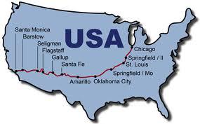
The 2,400-mile route winds from Jackson Boulevard and Michigan Avenue in Chicago to Los Angeles, through the most romantic and celebrated portions of the American West. Route 66 was a lifeline through much of America, connecting the small midwestern towns of Illinois, Missouri, and Kansas, with the big cities of Los Angeles and Chicago.


Route 66 is the National Old Trails Highway. On November 11, 1926 Route 66 was born. It followed the old trails laid out by the early explorers and railroad. Route 66  became the twentieth century version of the Oregon Trail, the golden road to the promised land and has inspired our spirit ever since. John Steinbeck called it the Mother Road, and indeed it was. It provided hope to the farmers of the dust bowl era going west to find a new life. It served our country well during time of war. In optimistic post W.W.II America, Route 66 defined a generation looking for adventure and freedom on the open road. To understand the history of Route 66 is to understand a little bit about ourselves, where we came from and where we hope to go in the future.

66 Diner in Albuquerque, New Mexico


Experience the Mother Road yourself; take a journey down the highway of dreams. This is her story, which really is our story after all. Maybe the times weren’t actually simpler back then, but it sure does seem so sometimes in our modern world.


click on any Route 66 state to begin your tour ~

Go West on Route 66

California

U.S. Route 66 States

Go East on Route 66

Illinois

NAVIGATION NOTE:  You can click on any Route 66 State or the East or West Route 66 shields to start your “travels” on the Mother Road in either direction. Pages will open to the particular state you choose, from there you will find an interactive state map. Drive your mouse along Route 66 by clicking on the map anywhere along the Mother Road to go to that area of Route 66. Route 66 is traditionally thought of as a east to west highway, the route from Chicago to LA. This web site is set up like that, as if you were going west on Route 66. But of course you can go anywhere and in any direction your heart desires.  Have Fun!

Now you can take a complete cyber tour of Route 66 from Chicago, Illinois to Santa Monica, California!  You can travel “Cyber 66” from start to finish ~ in either direction no less from the comfort of your own home.

[Top of Page]

Special Thanks: It took only four years, two cars, 33.75 thermoses of coffee, untold Snicker bars, 457 Tums, and 4566 photographs to complete this cyber tour of Route 66! What started out as a photographic journey to capture images along what I thought was a vanished road in Arizona and California expanded to encompass all of Route 66. What I found along the way has changed my life forever. Though Route 66 is no longer a US highway, it is far from being the lost and vanished road I once imagined it was. Route 66 is alive today and along her winding cracked pavement I discovered America. It was the America of my parents and grandparents, an America that I thought had been lost to us. The people of the Mother Road proved otherwise. It’s the people of Route 66, those that live, work and play along her corridor today that keep her alive. To those people I want to say thank you. None of this would have been possible without the help of you –  the special people I met along the way. To the business people on Route 66 trying to eke out a living away from the Interstate, the historians, the authors and artists who can see the bigger picture, dedicated volunteers and preservationists that strive to preserve this part of America for our children, the Route 66 State Associations and Organizations who know that to lose Route 66 would be to lose a part of our American soul, and above all, you road wanderers that take the path less traveled and know that it’s not the destination but the journey that counts – I owe all of you more than you could possibly know. Once you were strangers on a highway and the Mother Road brought us together as friends. To you then and all Road Wanderers I dedicate these pages. God Bless You All!


~ Guy Randall

24 January 2004


The Route 66 Caravan
Click the Logo

One of the most exciting things to happen on Route 66 in a long time! Through the support of Hampton® Hotels Save A Landmark program I accompanied Jim Conkle of theCalifornia Route 66 Preservation Foundation on a 66 day journey of Route 66 from Santa Monica to Chicago that started on  April 29th, 2003. I chronicled our adventures (some would say misadventures) down the Mother Road and posted a day by day account of our journey on the Route 66 Caravan web site. Catch the whole adventure here! Be prepared, there are 100 pages to peruse as this web site has become an online book.

Comments? Don’t be shy now!  I’d love to hear from you. You can contact me at:                

[ Click to E-mail Me ]


ROUTE 66 LINKS

Be sure to bookmark this page then check out the cool Route 66 Links by clicking on the Get Your Kicks link.

Great Route 66 Links
Get Your Kicks with Route 66 Links (click above)

How about your own web site? I design web pages for business and personal use alike. To find out more …

GRandall Web Design Service

Take a virtual tour of my N scale model railroad layout of a 1950’s Rocky Mountain mining town. Check it out …

Magnolia N Scale Model Railroad Layout
Visit Other Route 66 Pages in Web Ring Below

66ring.gif
Next | Previous | SkipNext | Email Ring Contact | 
Prev5 | Next5 | Random | Index | Join Ring ]

Have you seen my other Western Trails web pages?

  1900 Boulder, Colorado My Favorite Ghost Towns Rock Art